Next leg
Well the Admiral (Janice) just confirmed it. We leave for the Chesapeake the first week of August. That’s less than a week away. We have a lot of work to do to get ready. Janice is doing the provisioning, and I’m fixing the boat. For those of you who read all my previous posts you might remember I had a problem with my batteries not holding a charge to full capacity. I solved that riddle. The main house bank of batteries consists of 4 batteries in parallel. I disconnected them from each other after fully charging them. After about an hour all the batteries had a normal voltage except for one that was a volt lower (that’s almost 1/2 discharged). What was happening was the good batteries were discharging into the defective battery, lowering the total battery capacity. I just installed a new battery today.
My other job is to keep Janice from overloading the boat. If it were up to her she’d bring the kitchen sink. Catamarans don’t go very fast when overloaded.
The next post probably won’t be until we start the trip.
If it’s not one thing
In the process of “fixing the boat” I discovered that the hose that connects the seawater strainer to the engine water pump intake looked like it was on its last legs. If this hose failed not only would the engine not receive necessary cooling water, but the engine room would fill with seawater causing the boat to sink (The hose is below the waterline).
Well maybe I should have taken my chances. The strainer is located in a space that only a midget (little person) can reach. The engine side of the hose came off easily but no matter how hard I twisted and pulled I couldn’t get it off the strainer side. I finally ended up cutting it off. At this point I was black and blue and had numerous cuts on my fingers. I decided to wait until this AM to install the new hose.
I should mention that this is heavy duty hose with a wall thickness of 3/16″ and circumferential wire embedded in the rubber. Despite lubricating with Joy and using a heat gun to soften and expand it I wasn’t able to push it on to the “barb” on the strainer. I spent several hours trying (really) and am even more sore than yesterday
Tomorrow the plan is to remove the strainer from the boat and try again under more comfortable circumstances. Of course removing the strainer in such close quarters is sure to take off some more skin and add to my contusions.
Such are the joys of boat ownership.
Doesn’t look good
Looks like our trip will start a little later than planned.
I suppose we could try to outrun it, but….
Miracle
Miraculously the Tropical Storm that was supposed to become a hurricane after passing north of Georgia suddenly just disappeared.
Looks like we’ll be leaving Saturday AM. The ocean waters will be somewhat choppy over the next several days so we’ll probably take the inside route (ICW) until Tuesday.
Conundrum
It’s Saturday AM and we’re not leaving today. The weather picture is confusing. There is a low pressure system heading in our direction which is said to have a 70% chance of become a Tropical Storm within 48 hours. Even if it doesn’t intensify the area moving towards us is associated with severe thunderstorm activity. However, all the local wind and sea forecasts show light winds and seas 2-3 ft. They mention “scattered thunderstorms” but this is mentioned almost every day in Florida.
For those of you who have never been caught in a severe thunderstorm on a sailboat, let me tell you, it’s terrifying. Worse than the microbursts which can produce momentary winds of 50 kts, driving the rain and possible hail onto your face, and can cause a capsize if the sails aren’t reefed or lowered in time, is the lightning. There are things to do to mitigate the wind and heavy seas, but nothing to do to prevent a lightning strike. There you are, alone with nothing but the sea around you, with a 50 ft, aluminum lightning rod (the mast) reaching for the sky.
Being anchored in a thunderstorm isn’t much better. During the course of the storm the wind shifts as much as 360 degrees frequently causing the anchor to pull out with the danger of dragging onto shore. Or other boats around you dragging into you. This is particularly bad at night where it can be pitch black punctuated by everything lighting up periodically for a second from lightning. It’s surreal. Needless to say one doesn’t sleep through this.
It’s one thing to be caught up in a storm during a trip, but pretty stupid to leave a comfortable home knowing that a significant storm is predicted over the next 48 hours.
So do I believe the Tropical forecast or the local marine forecasts? Both are produced by the National Weather Service. Guess they are as messed up as the government.
Hopefully the situation will be clearer tomorrow AM which is now the earliest we will leave.
We’re off
The weather picture is no longer confusing. Emily is off to the NE and doesn’t appear to be a factor. We’ll be leaving this AM.
First Night

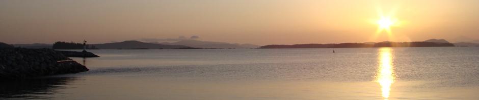
Well our first night. We’re anchored at Faber’s Cove near Ft. Pierce. We decided on a short first day run to regain our sea legs. (and Schooner’s).
While Emily is long gone, my fear of thunderstorms is justified. Just as we dropped anchor a wicked thunderstorm enveloped us. Luckily this cove is surrounded by homes land there are many open wifi sites. In checking the weather I came across this satellite image of our area (we’re a little north of that funny red thing near the East Coast. As the wind and storm is coming from the West I’m afraid we haven’t seen the worst of it. Should have stayed home another day or two.
In addition to the weather problem, the car radio which we use for XM satellite radio is dead. Janice won’t do overnight passages without her NPR. We’ll have to find a Best Buy or Wal-Mart and buy a new radio. I wonder when this trip will really begin.
I mentioned early that we’re lucky to be surrounded by private homes as far as wifi access goes. As the wind just picked up to 25kts with gusts to 30, the thought of the anchor dragging and ruining someones private dock makes me think this is going to be a long night.
Guess we haven’t really started yet
Day 2. As losing our car radio which we use for XM satellite, seemed to be a major problem we decided this AM that we had to replace it. The nearest place that had a Wal-Mart or Best Buy and had transportation to these stores was Vero Beach about a 15 mile trip. At this rate it will take about 2 years to get to the Chesapeake.
We stopped at the Vero Beach Municpal Marina mooring field. It’s wonderful here. Another name for this place is Velcro Beach. Named because once cruisers end up here they want to stick around.
Nice showers, lounge, large dinghy dock, free wifi, and best of all free shuttle buses to the shopping areas. All for $15/night.
I left Janice and Schooner at the nearby dog park and got on a shuttle. It was crowded, noisy and standing room only. It took about an hour one way, but what can you expect for free. Found a replacement radio at Wal-Mart and it actually fits in the slot left from the old radio
We’ll probably stay here another night for me to recuperate from the bus ride. I also have to change the engine oil. This place accepts used oil. I see why cruisers like it so much.
Oh yeah, of course there was another thunderstorm this afternoon but we were secure on a well maintained mooring ball.
Still in Vero Beach
Installed the radio this AM. Janice is now happy. Rained all afternoon. Spent the time reading and discovering new leaks (mostly around the windows. (another job).
Leaving tomorrow AM early for Titusville. From there we hope to leave the Ponce de Leon inlet and head straight to Charleston, S.C. We need to start moving.
Back home!
Yes, you read it right. We just got back home. We awoke early to take off to Titusville. As soon as I turned on the power it became apparent the depth sounder, speed, log wasn’t working. I took it apart and found it was soaked (water) inside from the recent rains. The seal had leaked (it was 16 years old.
I could do without the speed/log, but it would be dangerous to go on without a depth sounder. One isn’t needed in the ocean but when it comes time to anchor or explore small coves they are indispensable. I suppose I could use a “lead line” like the explorers did before electronics, but I’m spoiled.
My electronics man wouldn’t come to Vero Beach so we came home. It only took us about 6 hours, but of course we got caught in another thunderstorm.
Any we’ll have a new, more modern depthsounder tomorrow and will start the trip again on Saturday (weather permitting).
Chesapeake or Bust
Off again
Spent the last few days having a new Tridata (depth/speed/log) and new autopilot (old one was on it’s last legs) installed.
Finally everything is working and we plan to start again early tomorrow AM (unless the tropical depression heading our way worsens). This time the plan is to sail the ocean for several days and nights to make up for lost time. You may not hear from us for a few days unless I get cell service out there and can post on this blog.
Deja Vu
Things are never simple. The Tridata instrument that I had professionally installed was put in crooked. It worked but looked terrible. The head of the company who is a great guy agreed it looked terrible and sent another technician to re-install it straight. That took most of the morning, so we got a late start.
We decided to take the first day (again) of the trip easy and stop at the same place we did last time (a nice cove in Ft. Pierce).
We did this on the ICW because going outside and then back inside is actually longer.
Well about 1 hour from our destination we were caught in one of the daily thunderstorms. We could see it approaching on our radar, but not much a slow sailboat can do to get out of the way.
To prepare for the impending storm we put on our foul weather gear, life jackets, and prepared the ditch bag in case of a lightning strike. I wore Janice’s ski goggles because I couldn’t see through my glasses.
The wind wasn’t too bad but the visibility was practically zero. We couldn’t see the ICW markers and the radar was wiped out by the rain. I could get rid of the rain using the rain clutter control, but that also made the markers disappear. We basically steered using the depthsounder (see how important this instrument is), when the depth got below 8 ft. we knew we were at the edge of the channel. This lasted about 30 minutes and was no fun at all.
Soon after it cleared we arrived at the Cove which is surrounded by private homes. Our previous track is still on the GPS so we anchored exactly at the same spot and again have wifi.
We saw only one boat on the ICW the whole trip. This is off-season and I see why. I don’t want to go through a thunderstorm every day. I don’t know what’s worse, being on the ICW and not being able to see and possible end up grounded, or being on the ocean, getting hit by lightning, losing all electronics, possible holing the boat and sinking.
Ft. Pierce has an inlet so we can go on the outside tomorrow if we chose. We’ll make up our mind in the AM. For now we’re relaxing in this beautiful protected anchorage.
We finally did it
In view of the time we wasted coming home and fixing our broken instruments, and the fear of being caught in a thunderstorm and losing visibility on the ICW, we decided to go on the “outside” (ocean). We left through the Ft. Pierce inlet early in the AM, traveled all day, through the night and all day today. We arrived at St. Mary, Ga. Finally out of Florida.
The trip was uneventful, except for my watch at night. When lightning strikes even 20 miles away it lights up the night sky. You don’t necessarily see the strike, but the whole sky lights up in the distance. This was happening throughout the night. On my 36 mile radar I saw a number of storms that looked like they were going to intercept us, but none did, except for a little rain. When it was Janice’s turn to take watch I didn’t sleep very well. I made up for it after sunrise.
We had a pod of dolphins following us for what seemed like a half hour.
They might have stayed that long because they were curious about Schooner’s barking at them. They sure didn’t look scared. I got some short video clips of them (not very good), which I’ll upload in the future.
First thing we did when we arrived was to dinghy into the marina to take showers. When I closed my eyes in the shower it seemed like the room was rocking and rolling (like being at sea). I’ve experienced this before after being on a boat for a while. You get used to the rocking, so that when you’re on solid land, you’re not used to the stability. Janice experienced it as well. Don’t know about Schooner.
Will probably stay here another day, than move on. Would like to get to the Chesapeake before peak hurricane season in September.
Dolphins
I promised you dolphin videos. Unfortunately I’m not a nature photographer. I didn’t want to fill up my SD card with constant video so I tried to start the camera whenever I saw a dolphin. I was always late and there is a camera delay.
I’ve cut and spliced all my dolphin videos into a short segment. It’s not very exciting, but at least proves we saw some dolphins.
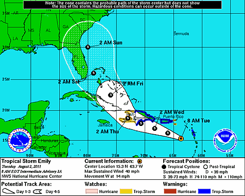
Hurricane Irene
We spent the last two days in the “sticks” of Georgia and South Carolina. Aside from the heat, humidity and large biting green flies the trip was nice. We anchored each night in small creeks off the ICW channel. We were totally isolated (no wifi or cell service) and surrounded by nothing but marsh. It was very quiet and we slept like babies.
We’re now in a marina in Beaufort, SC. As soon as I plugged in I checked the weather and noted the projected tracks for Irene. One of them has her going into the Gulf of Mexico (good). Most of the others have her hitting Florida then running up the East Coast (bad). It doesn’t look like we can avoid her (assuming she stays on track). We’ll just have to find a hurricane hole or Marina, tie the boat up as well as we can, get off the boat and try to find a shelter that will allow dogs.
Not looking forward to it.
We can’t escape
Latest hurricane track is for Irene to hit the junction of N and S Carolina on Saturday.
We’re currently near Charleston S.C. We’re heading for Myrtle Beach, S.C., should reach there on Wednesday.
Why Myrtle Beach (exactly where the current track is headed)? We spent the day (while traveling) calling various marinas on the way. None of them would allow us to dock there during a hurricane. (Fear of us damaging their docks). We finally found a marina in Myrtle Beach. Interestingly it is quite cheap and gets excellent reviews in the cruising websites. We’re looking forward to arriving.
We’ll tie up Latitude Adjustment as best we can, maybe rent a car and drive as far inland as we can.
If we get a direct hit at a Category II or III I don’t think there’s much chance the boat will survive. That would put an early end to our trip.
Myrtle Beach
 We arrived this afternoon at the only marina that would let us stay during a hurricane. I can see why. The marina is in a basin several hundred feet off the ICW completely surrounded by dense trees and mangroves. There is no fetch, therefore no waves. I’m told also there is no surge. The boat should be pretty well protected here unless another nearby boat breaks loose and hits her.
It’s looking like we’ll probably only get 30-60 kts of wind if the projections are correct. If Friday the projections are toward the low-end we’ll stay on the boat, otherwise we’ll find a motel.
Waiting
 A better photo of Latitude Adjustment demonstrating the “hurricane hole” aspects of our marina.
We met 3 other boats here in the same situation, i.e. traveling and ducking into this marina to wait out the storm. We all decided to stay on our boats to protect them rather than retreat to a hotel room.
The scary thing is the remainder of the 60 odd boats here are permanent residents and we didn’t see any of them coming around to secure their boats. The boat behind us seems reasonably secure but if a few boats become loose there could be a domino effect.
The local weatherman here predicted 30-40 kt winds but as the track moved a little west he now predicts 30-50 kt. Boats at 50 kts are probably safer at sea (nothing to crash into) but the seas are expected to be 22 ft. I don’t think I want to do that.
The storm is expected to hit us tomorrow night but if it hits or is still going during the day I’ll try to get some videos or at least photos.
It’s getting dark
 Well our preparations are complete, now we just wait. The worst should happen at 2 AM tonight.
While killing time surfing the net I came across this photo. Not reassuring.
Anticlimactic
It’s 6AM here, still dark. Luckily Irene weakened through the night (now just Cat 1) and the eye came no closer than 125 miles of us. We slept like babies through the worst of it. No damage (except for some leaky windows). Our 9 dock lines held as did the dock. I haven’t checked the rest of the marina yet, but if any boats broke free they didn’t hit us.
We’ll stay here a few more days waiting for the seas to calm.
We could be stuck in worse places. The full name of our marina is “Osprey Marina & Grill” (really). Food is wonderful, and Janice is thrilled not to be cooking on the boat.
This is what we were trying to avoid!

Boring
After all the excitement of Hurricane Irene, I’m back to just reporting our progress.
We left Myrtle Beach early this AM, encountered lots of fog. Had Janice at the bow blowing our foghorn, while I had my eyes peeled on the radar. Reminded me of our travels in Maine. After a tense hour or so, the fog lifted and we had an uneventful cruise to Southport, N.C.
Currently we’re at the free dock of a restaurant we just ate at called the Provision Company. Actually had good seafood, and with the free overnight dock, a real bargain.
We’ll be leaving tomorrow AM early. We want to make up the time we spent waiting for Irene to pass.
Oriental N.C.
We left the free restaurant dock at Southport 2 days ago. We spent yesterday night anchored in a Marine base (Ft. Le Jeune). We were buzzed by helicopters, had multiple dinghies with armed marines landing on the beach (practicing obviously), and heard much artillery in the distance. Luckily it all quieted down after dark and we had a peaceful night.
We left this AM and after traveling for 30 minutes were stopped by a Navy patrol boat. The were conducting artillery practice across the ICW in front of us. We had to anchor and wait an hour before we could go on.
The remainder of the trip was uneventful. We saw minimal damage from Irene and there was minimal debris in the waters of the Neuse River despite what had been reported.
We arrived a little while ago in Oriental expecting to anchor but luckily the free Town Dock had an opening and we’re docked here. It’s right in the center of town, unfortunately the street in front of us is flooded, there is no electricity and the town has to boil its water. They were hit hard. We can stay here for 48 hours and will explore the town tomorrow. Hopefully the water in the streets will have subsided.
Check out www.towndock.net , click on the right side of page “harbor cam” and you’ll see us live (as long as we’re still here).
We made it to Chesapeake

Chesapeake, VA that is. We’re still about 12 miles from the mouth of Chesapeake Bay.
We’re at a free dock just north of the “Great Bridge”. We’re just south of the “Great Lock”, which we’ll lock through tomorrow AM.
We just got back from a shopping trip. Walked about a mile to a shopping center and stocked up on toilet paper and dog food. Can never have enough of either.
Death on the ICW
Spent our second day at the free dock in Chesapeake, Va doing more shopping.
We met a liveaboard here who pointed out one of the reason there are so many flies here is that several days ago a boater smelled a terrible smell from a boat 2 boats down from us. He called the police and to make a long story short, they discovered a dead sailor in the boat. It was estimated that he had been lying there for about 5 days. It was assumed he died of natural causes.
They took out the body, but unfortunately nobody claimed the boat and it’s still here. Flies and all. Glad we’re leaving tomorrow AM. We’ll be locking through the “Great Bridge Lock” and expect to anchor just north of Norfolk, VA.
Can’t assume I’ll have WiFi there.
Onancock
We left the dock at Chesapeake early yesterday. We were the only boat locking through at that time. The lock brought us down about a foot. Almost didn’t seem worth it.
We spent last night at Willoughby Bay. It turned out that there is an air military base nearby and thought the afternoon we got to watch helicopter maneuvers. Was pretty interesting (and noisy).
Hurricane Katia will be passing Norfolk (several hundred miles away) tomorrow and the seas are already being stirred up. The weather today was the last acceptable day until the weekend, so we decided to travel north to a place we’d like to stay until then.
We chose Onancock, VA as our destination because of the rave reviews it received from Larry and Jane (commentators on this blog).
It turned out to be the trip from hell. The winds were 25 kts with gusts to 30. The seas were 3-4 ft with the occasional 5-6 footer. It wasn’t much fun, but at least we got to sail rather than motor. With one reef in and the jib half furled we hit 12 kts and averaged 8-9.
We are currently anchored just outside the marina here and will check into the marina tomorrow AM. Janice is thrilled.
Lucked out
We’re in the Onancock marina now. Did we time things right. Tomorrow and the next day they’re having their “Harborfest”. If you’re interested in what this is check out the link www.onancock.org.
We’ll be here 3 nights then will be sailing to Tangier Island.
Tangier Island
 Spent the day and night at Tangier Island yesterday. Wonderful, strange place. Population is about 700. Most people share the same last name. The island makes it’s living from crabbing and a little bit from tourism. The island can only be reached by boat or plane. People are very friendly.
One of the outstanding features are the number of cemeteries. Again most of the tombstones are familiar names. Some people have graves on their front yard. Probably everyone who has died on the island has an identifiable grave here.
The owner of the marina here, Mr. Parks is 80 years old. He has no employees it seems. He offered to take us on a golf cart (there are no cars) tour of the island but it started raining.
We left there this AM and we’re now anchored off Oxford , MD. (a 10 hour trip). We’ll explore the town in the AM.
St. Michaels
 Exhibit at St. Michaels Maritime Museum
I couldn’t post from Oxford because there was no wifi. We spent 2 nights there. Small prosperous town that looks like it should be located in New England (house style). It’s definitely not a tourist town. Only 2 restaurants and one was closed. One market, no “attractions”. Seemed to be more boats (in the marinas) than people.
Did I mention that Tangier is a “dry town”? (I know that is a non sequitur).
The sail from Oxford to St. Michaels was interesting in that we encountered much debris (mostly logs and tree branches) in the water. From what I gather there are flood gates in the northern Chesapeake that were opened after Hurricane Irene. As the flood waters entered the Bay the debris came with it. It wasn’t a pleasant sail for this reason.
When we got to St. Michael we noted the two inner harbors were pretty crowded. We read that the holding isn’t that good and I don’t like things going “bump in the night”. So we anchored just outside the harbors in the Miles River.
We explored St. Michael yesterday. What a contrast to Oxford. It’s a real tourist town. Lots of restaurants, bars, museums, tours etc. There is a dinghy dock just for the visiting boats. I see why this is such a popular cruising destination.
Right now we’re sitting in the boat reading and catching up on computer stuff (as we have wifi). The winds have picked up to 15 and expected later to be 20 kts with gusts to 30. Because we’re unprotected and the wind is coming down the river we have waves and don’t want to take the chance of being marooned on shore (our dinghy and 2 1/2 HP motor are not suitable for significant waves), so we’re going to stay on the boat all day. Weather is expected to be better tomorrow.
Our next stop is Annapolis or more precisely Edgewater, MD (a suburb). The annual Annapolis SSCA (Seven Seas Cruising Association) gam (convention) is Sept 23-25. We’ll get there around the 20th and hope to meet two of my cousins. After the meeting is over we’ll slowly start our way home visiting places we missed on the way up.
Western Shore
Two nights ago while anchored outside of St. Michaels harbor in the Miles River, the winds picked up to 25-30 kts. They were from the north and the river runs north-south. There is a nautical term called “fetch”. This refers to the distance the wind has to work on the water to create waves. The longer the fetch the higher the waves. Well there was more than 5 miles of fetch and the waves were 2-3 feet. This is not much while traveling but horrible when you’re anchored. The dinghy was bobbing up and down and making noise as it splashed down. We didn’t get much sleep that night. At least we were by ourselves and had no fear that another boat was going to break loose and hit us.
The next day was relatively calm. Other boats “joined” us. Some cruisers are like lemmings. Here we were all by ourselves on this large river with room for hundreds of boats. Someone comes up to us and anchors about 30 ft. away. Than another, and another. All of us packed into a little area leaving 90% of the anchorage empty. I suspect when the first boat saw us there he figured we must know where to anchor, than the second boat saw 2 boats so he was sure where he should anchor, and on and on.
We left the now crowded anchorage this AM and sailed (not motored) to the West Bank of the Chesapeake, up the West River and anchored off a town called Galesville. I don’t know anything about it, but we have free wifi, so I’m not complaining.
Tomorrow we go into a marina for 2 days so Janice doesn’t go crazy.
SSCA
We’re at the SSCA (Seven Seas Cruising Association) gam (convention) near Annapolis, MD. This organization is the premier cruising organization in the world. It’s ranks include many circumnavigators and the elites of the cruising world. The 3 day meeting includes seminars, vendors displaying their wares and most important the ability to socialize (party) with like-minded people.
We got here a few days early to get a good spot in the anchorage. We only have a short ride to the dinghy dock.There are currently 42 boats in the anchorage and many more will come by car.
It’s been cloudy and raining since we arrived and expected to continue that way through the meeting.
Luckily the rain broke last night to allow a party on the beach of a small island in the anchorage. We met a lot of interesting people there and Janice met a couple who attended her High School in Portland (small world).
Coming home
 The SSCA gam is over. We had a great time, met many interesting people. We also met three of my cousins who live near Washington, DC.
We’re on the way home and expect to be there towards the end of October (barring any hurricanes).
We’re currently anchored in a small cove on Solomons Island, MD
Caught in the storm!
The following takes place 2 nights ago. Haven’t had wifi access since so couldn’t publish it then:
We spent a peaceful night at anchor in the Antipoison River in Virginia, near Deltaville. No internet or cellphone service.
Still in the Chesapeake, our next stop was to be Norfolk where we would enter the Intracoastal Waterway. Winds were against us for the first part of the day so we motored. Winds changed and we sailed.
Everything was going well until our VHF radio beeped loudly, an emergency broadcast from the National Weather Service. The terse announcer said,”A line of severe thunderstorms capable of producing winds of 50 kts, hail, water spouts and lightning strikes is heading for the Norfolk area.” We were 3 miles north of Norfolk. We immediately started the engines and took down all sail. As the sky darkened we reached the channel into Norfolk. The current was against us at 2.5 kts. Our speed over water was 7 kts, but our actually speed via GPS was only 4.5 kts. The storm moved towards us at 15 kts. There was no way we could outrun it. Janice put the dog in the salon and cinched on his life jacket.
We abandoned our original destination and headed for Willoughby Bay, a mile from our position. We reached the bay and luckily there were no other boats there. Suddenly, we were hit broadside by a 50kt gust of wind and hail. Lightening hit the water all around us. It felt like the oxygen had been sucked out of the air and Janice almost fainted. Even with no sail up Latitude Adjustment began to heel (cats aren’t supposed to heel). I tried to turn her into the wind, but the wind kept shifting. Visibility was zero. I told Janice to drop an anchor and we came up with a plan, but soon realized that it was too dangerous to send her up front. If she fell overboard that would be it for her.
My next goal was to keep the boat towards the center of the bay in order not to be grounded or hit anything near shore. Radar was useless; all we could see was rain clutter. The only navigation method I had was the GPS chartplotter and it jumped all over the place.The wind driven rain and hail hurt my eyes. Janice gave me her ski goggles.
As quick as it came on us it stopped. The sun came out and we saw a beautiful rainbow. More importantly we were in the middle of the bay away from all obstructions. The entire experience probably lasted about 20 minutes but it seemed like hours. We were soaked. The radio barked warnings about tornadoes in the area. On shore, we could hear warnings to employees to get inside.
But wait. It’s not over. We anchored in the protected portion of the bay and as soon as the anchor was down another storm cell hit us. We sat in the salon and watched as we were pushed close to two anchored barges. Then we swung close to a small sailboat anchored near us. Then we saw a channel marker behind us. The anchor must have dragged more than 200 feet. Just as I was about the start the engines and take the pressure off the anchor line, it was over. This anchor has never dragged before. Never. For you sailors, we had 10:1 scope out.
We re-anchored, and we watched nature’s fireworks for the rest of the day and that night until about 8 PM.
Catching up

Since the storm things have been routine, but interesting and fun.
We proceeded down the ICW and entered the “Great Dismal Swamp Canal”. This is a 22 mile stretch that looks like it came out of the movie Deliverance. It’s quite narrow, when two boats have to cross in opposite directions both have to slow to a crawl to avoid hitting each other (we only had one crossing the entire stretch). Most

cruisers take the Virginia Cut which is faster but less rustic.
To enter the canal you have to go through a lock that raises the boat 8 ft. This takes about 30 minutes during which time we had a conversation with Robert, the lock keeper. He gave us a lecture on the history of the area. It was fascinating, but the usual 30 min period turned into an hour. In the meantime

there was another boat waiting to go through the lock. Right after the lock we found a free dock. It’s by a town within easy walking distance so we went grocery shopping and had dinner at a small but wonderful Mexican restaurant. We had a restful sleep that night.
The next morning we continued on and left the canal after going through a second lock which dropped us 6 ft. (I don’t know where the missing 2 ft. went).
We continued on to Elizabeth City where there was more free docks. The people of the city are very cruiser friendly. For years a group known as the “Rose Buddies”, greets cruisers at the docks and if there were more than 4 boats would host a wine and cheese party. We were lucky enough to attend one of those 6 years ago, but for some reason they didn’t have one this time. We were however treated to a farmers market right next to the boat.
We might a nice Canadian (Nova Scotia) couple who told us about a city named Manteo on the outer banks of NC. It was a little out of the way and we hadn’t planned to go in that direction but it sounded so nice we decided to go out of our way. Both boats left together but our cat was much faster and we arrived first. Guess what, another free dock.
Tomorrow we leave early for Ocracoke also on the Outer Banks.
Nervous

We left Manteo and had a beautiful windy 60 n.m sail to Ocracoke. We averaged about 8 kts. We quickly toured the town (which was quaint) and decided to move on as we’re getting anxious to return to the comforts of home.
We left Ocracoke in 20 kts of wind. I decided to take a channel out of town (to the Pamlico Sound that isn’t listed in any of our guide books. The depths were all over 8 ft so I figured it would be a piece of cake. The channel is several miles long. Half way through the waves became 3-4 ft high. It occurred to me that our bottom (we have a 4 ft draft) might hit bottom with a thud in the trough of a wave. By that time were were past the point of no return. It was quite nerve racking but we never hit bottom and got into the Sound. It was a close reach (about 60 degrees to the wind) all the way to Neuse River which got us back to the protected ICW. We anchored at Cedar Creek with 4 other boats. Coincidently one of the boats knew my fellow Lagoon 35 owner and email friend Marshall. He introduced himself and took a photo of our boat to send to Marshall. For some reason though the photo Marshall received was of a different catamaran?
The next morning we motored from Cedar Creek to Mile Hammock Bay. We stayed there on the way north. It’s on Camp Lejeune marine base. There was only one other boat on this large bay. We had purchased the recent version of Skipper Bob’s ICW guide. Going north we used one that was 6 years old. The newer version mentioned that they had received reports of boats being ordered to leave day or night when the marines wanted to use it for maneuvers. I spent the whole night worrying that that would happen and we’d have to travel the ICW in darkness 3 in the AM. Of course it didn’t happen.
We left there this AM with Southport, NC as our destination. We had stopped there on the way north and stayed at the Provisions restaurant dock. The food is great and the dock is free, what more can one ask for.
This trip the wind was directly behind us at 20-25 kts. The current was against us. In the situation on the Cape Fear River (I know now how it got its name), large, closely spaced waves develop. We experienced 3-5 ft waves closely spaced. We’d ride up the crest of one and drop to about 2 kts, than down the next we’re we hit 12 kts. It was quite a ride for a couple of hours. Was glad to reach Southport harbor.
We may spend a second day here. Obviously we have internet access.
Stuck
We’re anxious to get home but the weather isn’t cooperating. It’s expected for the wind to be 20-25 kts with gusts to 30 and seas 5-8 ft. until Wednesday. We try to be fair weather sailors. It’s one thing to be caught out in a storm but considering we’re safe on a free dock at a good restaurant in a nice town, Janice thinks we’d be crazy to leave with that forecast.
We hope to make up the time by finding a good weather window and traveling the ocean several days and nights straight.
As of now we’ll be leaving on Wednesday (but of course that can change).
Flesh eating bacteria
This AM after spending a night in the rain in an isolated anchorage between Myrtle Beach and Charleston we attempted to weigh anchor. The wind was 20kts with a 2 kt current in the opposite direction. The anchor rode instead of being in front of the boat, went under between the 2 hulls. We hard an awful time trying to raise it. At one point I grabbed the chain with my hand at the bow roller. I couldn’t hold it and in the process of trying to release it my hand was trapped between the deck and the chain. It felt like my fingers had been crushed. My first thought was that I had lost my fingers and wouldn’t be able to use my computer (my favorite activity). I soon realized my fingers were intact but the flesh was missing over 3 of the digits. There was blood all over the foredeck and some dripped all the way over the side deck into the cockpit in my rush to get inside and dress my wounds.
It took us an hour but we finally got the anchor up. My thoughts then went to the memory of a friend in Stuart, a retired physician, who was fishing in the ICW near Stuart. He cut the skin on his hand and within 2 hours was deathly ill. He went to the ER and told them he thought he had flesh-eating bacteria, and this was confirmed. This is a serious illness that can lead to death with 24-48 hours. I worried that if this happened to me I would be nowhere near medical care, and we didn’t have any antibiotics in our first aid kit (it wouldn’t have mattered as this infection needs to be treated with high dose IV antibiotics).
I sweated for the next few hours. I’m still here so I guess I didn’t get it <g>. I’m still a little concerned that my wounds might become infected, but at least I’d have some time to find medical care.
We expect to reach Port Royal inlet tomorrow and sail on the outside to St. Mary’s GA. That’s just a couple of days (and night) from Fort Pierce. Almost home.
Back to Florida
When we started this trip we were thrilled that after our overnighter on the outside we had left Florida behind. Now after an overnighter on the outside we are in St. Augustine, Fl and thrilled to be back in Florida. We had a beautiful moonlit over night sail about 15 miles offshore. The only thing ruining it was when I noticed on my chartplotter the phrase “Northern Right Whale habitat, do not approach within 100 yards of a Right Whale. I spent many hours worrying that we would hit a sleeping whale and sinking the boat. Even with a full moon I don’t think we could have seen a whale at night.
The weather is supposed to be terrible tomorrow so we will stay here in the mooring field for a second night.
Almost home
We’re in Cocoa, Fl, just south of Cape Canaveral. One more days travel we’ll be in Ft. Pierce which is just about home (5 hours). We’re really looking forward to it. We love cruising (still) but after our 3 year trip we’ve had it being away from the comforts of home so 3 months is enough for this trip. It’s also getting pretty cold and with the wind on a sailboat, pretty uncomfortable. Today I wore a t-shirt, sweater, sweatshirt over that and an insulated jacket over that. I wore a wool watch cap. It was still cold. Our boat has air conditioning, but no heat.
Fort Pierce
After motoring south on the ICW for 9 hours we’re now anchored in Faber Cove (a favorite of ours) in Fort Pierce. Only about 30 miles from home. I wasn’t going to write another post until we got home, but having a good wifi connection I couldn’t resist.
Tomorrow will be my last post (if I can get my home internet connection turned back on) until our next trip.
Home!
We reached our home dock at about noon today. Now the hard work of unpacking the boat, putting things away and re-organizing our lives. We’re thrilled to be back, but can’t wait for our next adventure.
Hope you enjoyed our blog.
I’ll have more to write when we go on our next trip.